
- Community Briefing Note 09
You can still swim at Matilda Bay. But where, and will you want to?
METRONET on Swan Ferry Expansion
Damien Smith
22 September 2026
Minister Rita Saffioti has reassured the community that people will still be able to swim at Matilda Bay after the proposed ferry service begins operating. The Government has said that existing water activities can continue with “adjustments”, including a wide exclusion zone where the ferry would not go.[i]
That raises two fairly obvious questions: where will you be able to swim, and what will the water around the terminal actually be like?
Exclusion zones work both ways
A high-frequency passenger ferry cannot safely operate in the same piece of water as swimmers, kayakers and paddleboarders without some form of separation.
If exclusion zones are part of the proposed safety system, Government should be able to show us where they are.
Recently, Government has begun talking about a ferry exclusion zone, meaning an area where the ferry will not operate. But an exclusion zone works both ways. Once the ferry route, approach and manoeuvring area are fixed, people also have to stay out of the water being used by the ferry.
This is normal around busy ferry terminals. Swimming is prohibited at Elizabeth Quay inlet.[ii] For the Kamay ferry project in Botany Bay, the wharves were deliberately located away from popular swimming areas to provide swimmers with a buffer from ferry operations.[iii]
Matilda Bay is different because swimming, kayaking and paddleboarding already occur throughout the sheltered water around the proposed terminal. DBCA itself describes Matilda Bay as having sheltered, calm water suitable for swimming and kayaking, and lists swimming, canoeing and kayaking among the reserve’s activities.[iv]
At one of the stakeholder meetings I attended, we specifically asked about exclusion zones. The Government representative wrote “EXCLUSION ZONES” on the whiteboard in large letters and nodded.
Stakeholders still have no idea where those exclusion zones will be. It remains another significant gap in the operating plan. Surely the Operations Development Application should show the community what the arrangement will look like?
At present, it does not provide a simple map showing the ferry operating corridor, manoeuvring area and the areas that will remain available to swimmers and other recreational users.
What happens to the bottom?
Large ferries manoeuvring in shallow water move a lot of water through their propulsion systems. Where that flow reaches the riverbed it can disturb sediment and, with repeated operations, progressively scour the bottom.
Government’s own coastal engineering consultant, Seashore Engineering, identifies vessel scour at the Matilda Bay berth as a potential impact and recommends further evaluation and mitigation.⁵
The material scoured from the bottom does not disappear. Coarser material settles nearby. Fine material can remain suspended in the water, making it cloudy and increasing what water-quality specialists call turbidity.
Anyone who has sailed dinghies in Matilda Bay will be familiar with a “choc top”. Capsize in shallow water and the top of the mast and sail can dig into the riverbed. When you right the boat, the top of the sail comes back covered in horrible fine silt which takes ages to wash out.
So when we talk about fine sediment and turbidity at Matilda Bay, this is not some theoretical material which may or may not be present. It is sitting there on the bottom now.
Government’s own sediment sampling gives us a better idea of just how fine some of it is.
Settling times of sediment from the proposed ferry landing sites
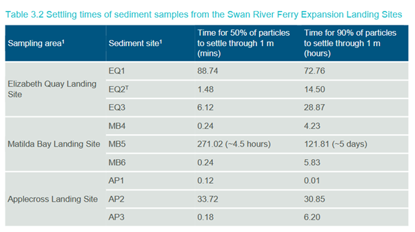
At Matilda Bay sampling site MB5, BMT found sediment composed predominantly of silt.[v] Its calculated settling time for 50% of the particles to fall through just one metre of water was 271 minutes, or about 4.5 hours.
For 90% of the particles to settle through one metre, the calculated time was 121.81 hours, or about five days.⁶
The result makes the underlying issue fairly clear. Some of the fine sediment at the proposed Matilda Bay landing site does not simply drop straight back onto the bottom when it is disturbed. A fine fraction can remain in the water column for long periods.
Turbid water does not automatically mean polluted or unsafe water. But it does mean murkier water, reduced light penetration and suspended sediment which eventually has to settle somewhere.
For a place promoted by DBCA for swimming, paddling and other recreational use, the scale and frequency of that effect should be understood before ferry operations are approved.
“No dredging” is not the same as “no seabed disturbance”
Government has emphasised that the Matilda Bay terminal has been designed to avoid dredging. The Government’s own dredging assessment concluded that dredging was not required for the proposed preliminary terminal layouts.[vi]
Avoiding dredging is obviously desirable.
But if repeated ferry manoeuvring progressively scours the riverbed, the sediment is still being moved. The mechanism is different, but the result still needs to be understood.
Questions for Government
Please publish a map showing the proposed ferry operating corridor, manoeuvring area and all exclusion or separation zones, including which areas of Matilda Bay will remain available for swimming, kayaking and paddleboarding while the ferry service is operating.
What vessel-specific work has been undertaken to predict seabed scour, sediment resuspension and resulting water-quality impacts from repeated ferry operations at Matilda Bay? Please publish that analysis, including the predicted scour area, turbidity and sediment dispersion.
The Minister may be right that people will still be able to swim at Matilda Bay.
But before the ferry operation is approved, the community should be shown where.
And what they will be swimming in.
Endnotes
[i] Nicolas Perpitch, “WA government committed to Matilda Bay ferry plan as opponents highlight safety risks”, ABC News, 15 September 2026
[ii] https://developmentwa.com.au/projects/redevelopment/elizabeth-quay/enjoying-swan-river
[iii] NSW Department of Planning and Environment, Kamay Ferry Wharves Assessment Report, 2022
[iv] Department of Biodiversity, Conservation and Attractions, Matilda Bay Reserve, Explore Parks WA. DBCA describes the water as sheltered and calm and suitable for swimming and kayaking
[v] Seashore Engineering, Swan River Ferry Expansion Project, Perth to Applecross: Preliminary Coastal Process Impact Assessment, 5 September 2025, prepared for the Public Transport Authority
[vi] BMT, Assessment of Dredging Requirement for Swan River Ferry Expansion, Applecross and Matilda Bay Terminals, 12 June 2025